A Kingston Hills & Kingston Woods history

The Luxmore Woods Story

How neighbors stopped an apartment complex in 1997, and the City bought the woods for a park.

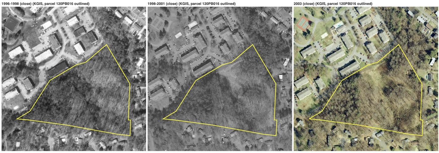
Three aerial photos of the parcel outlined in white: wooded in 1996–98, largely cleared in 1998–2001, and growing back in 2003.
The woods from above, outlined: before the clearing (1996–98), cleared (1998–2001), and growing back (2003). KGIS aerial imagery.

The woods before 1997

The 12 acres at the end of Luxmore Drive were never part of the neighborhood around them. In 1975 the Ohio company connected to the apartment complex below the woods passed the tract to a group that included Oliver Smith Jr. and Dr. John Montgomery Sr. and Jr., developers of West Town Mall. By 1993 Dr. John L. Montgomery Jr. owned it alone.

Knox County had zoned the land “RB,” general residential. At the time that meant apartments could be built there next to single-family homes without any public hearing. The land is steep, and its only road connection is the dead end of Luxmore Drive, with the apartment complex below on the other side.

THE WOODS 12.36 ACRES · CITY-OWNED SINCE 1997 APARTMENTS (TIMBERS WEST, NOW THE DISTRICT) KINGSTON PARK TRAILS WEST KINGSTON HILLS RAMSGATE DR LUXMORE DR only road access N
Drawn from the survey description in the 1997 deed (Sizemore-Lynch, March 1, 1997). Approximate: the deed's measurements do not close exactly, and streets are schematic.

Spring 1997: the apartment plan

In March 1997 the woods were surveyed. In April the Montgomery family formed a company, Montcarl, LLC, and moved the land into it. Then, as a homeowner later told the paper, “bulldozers showed up one weekend.”

Dr. Montgomery and Mike Carlton planned about 100 small apartments, and every car would have come and gone through Kingston Hills on Luxmore. On May 27 a paid notice in the News-Sentinel called on neighbors to pack that night's County Commission meeting.

The neighbors organize

Residents of Kingston Hills and Kingston Woods went to the Commission “en masse,” but their complaint was postponed. A committee then asked Dr. Montgomery his price for the land. He asked $640,000, and, by one account, had been offered $125,000 a year earlier. “We raised $250,000 in three days,” one of them later said. “But we couldn't negotiate the price down. So we had to find a buyer with some money.”

Joining the city

The neighbors turned to the City of Knoxville with an offer: annex our homes, and the new city property taxes will pay for the woods. A petition drew about 290 signatures in a few days. On August 11, 1997, City Council held a special meeting in a yard in the middle of Kingston Woods and voted to annex the neighborhood and buy the tract. Mayor Victor Ashe told residents the apartments would have played “havoc with your neighborhood,” and said the majority of homeowners agreeing to join the city made the purchase cost-effective.

At the final vote on August 26, residents spoke only in favor and every vote was unanimous. The plan the City adopted for the annexed area says “a greenspace area of about 16 acres will be set aside within the community.” Annexation took effect at midnight on September 26, and that day KUB began putting up the neighborhood's first street lights, starting at Ramsgate and Luxmore. Homes whose owners did not sign stayed in the county, leaving what the paper called a checkerboard; in all, 278 homes came in that fall.

The City buys the woods

On October 9, 1997 the City bought the woods from Montcarl for $523,188 through its Parks and Recreation department, and the next day began stabilizing the bulldozed ground. City officials said they planned “to restore the land to a passive green area.” The deed itself carries no park restriction.

Since then

The cleared slope has grown back into woods. The City has treated the land as a park: it rezoned it as a “City park” in 2003, listed it among its parks in 2010, and named it a Nature Conservation Park in its 2026 parks master plan. No trails or facilities have been built, and the City's one-year land-use map still shows the parcel as residential.

Some 1997 records are still being requested from the City, including a memo on the proposed “Kingston Woods Park” written the week before the final vote. The timeline below lays out every step with its source, and the documents are linked at the bottom of the page.

$523,188City purchase, Oct 9, 1997
~290homeowners asked to be annexed
12.36 acparcel 120PB016
16 acresof greenspace promised in 1997

What each record means today

A neighbor asked a good question: how can the woods be a conservation park when the City's land-use map says residential? The answer is that different documents do different jobs, and only one of them controls what can be built today.

RecordWhat it saysWhat it doesWhat it does not do
ZoningNA, Natural Areas. The City rezoned the woods to open space as a "City park" in 2003.Controls what can be built today. Housing would need the land rezoned, which goes through a Planning Commission hearing and a City Council vote.It is not permanent. Council can rezone land.
One Year Plan land-use mapMedium density residential.A planning guide that planners check a rezoning request against.It does not allow anything to be built by itself. The 2003 rezoning report said it would be changed to show the site as public land; it has not been.
2026 parks master planNature Conservation Park #6 and Significant Natural Area #7.Sets how the parks department plans for the land.It is policy, not a legal protection, and it lists no project or budget.
1997 annexation plan of services"A greenspace area of about 16 acres will be set aside within the community."The City's written commitment when it annexed the neighborhood.It does not name the parcel. Whether it can be enforced today is a legal question.
1997 deedThe City of Knoxville owns the woods, bought through Parks and Recreation.Establishes ownership.It carries no park restriction, so it does not by itself prevent a sale or other use.

Questions neighbors can ask the City

This summary describes what each document says. For how much legal weight each one carries, Knoxville-Knox County Planning or an attorney can confirm.

Timeline

Each entry says where it comes from and links to the document when there is one. Quotes from the 1997–98 Knoxville News-Sentinel appear on the day they ran; the full pages are in the paper's archive, free with a Knox County Public Library card.

The long view

1966 to 2026 · tap a marker to jump to it

Swipe sideways to see the whole chart.

1997, month by month

from survey to purchase

Documents

Every file is a public record. The tag under each one says who holds the original and how it was obtained. KGIS is the Knoxville-Knox County online property map, which links recorded deeds and planning cases. A few terms: a quitclaim deed hands over whatever interest the signer has; an ordinance is a City law and a resolution a formal Council decision; RB, R-1 and OS-1 are zoning categories (county general residential, city single-family, city open space).

1997 annexation

The purchase and the deeds

Zoning and planning

Maps and aerial photos

Still unknown

    Add a document, a memory, or a correction

    Messages go only to the neighbor who keeps this page. The site counts visits anonymously and does not record who you are. Name and email are optional; leave an email if you'd like a reply.

    optional
    optional
    optional, up to 8 MB